Official Name:
赵渠村山险ZhaoQuCunShanXianOur Name:
/
Other Name:
/
Period:战国秦
/ Warring States 475~221 B.C.
Location: 甘肃省,庆阳市,镇原县,起点:马渠乡红光村石咀山组西北600米石咀山山口处止点:马渠乡赵渠村佛庄组西北1.49千米长咀梁梁头上(佛庄1号敌台) / GanSuSheng,QingYangShi,ZhenYuanXian,QiDianMaQuXiangHongGuangCunShiJuShanZuXiBei600MiShiJuShanShanKouChuZhiDianMaQuXiangZhaoQuCunFoZhuangZuXiBei149QianMiChangJuLiangLiangTouShang(FoZhuang1HaoDiTai)
[
Looking Local List]
Details:长城类别:墙体
起点经纬高度:东经:106° 56′ 北纬:36° 00′ 海拔:1405
终点经纬高度:东经:106° 56′ 北纬:35° 59′ 海拔:1540
墙体走向:
墙体类别:山险
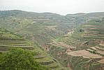
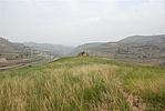
结构特点及构筑方式:无。赵渠山险起自GPS045点,止于GPS047点,全长2910米,保存一般。本段山险主体由东北向西南延伸,从石咀山山口开始,这段沟谷交汇,山高沟深,人畜几乎不能翻越,所以长城建设是以利用石咀山与石涝子沟壑共同作为天然屏障的;但是在山险内部的某些制高点有修筑烽火台,以提供军事信息和通讯联络,GPS046点(石咀山烽火台)便是赵渠山险内侧制高点上的烽火台。GPS047点既是赵渠山险的止点,也是赵渠长城1段的起点,同时也是佛庄1号敌台所在地。
现状:
Type:山险 Precipitous mountain areas
Protection Level:
Content:
Memo:
Other Records:
Distribution:
visit location in Tianditu Map[recommend] Distribution:
visit location in Tencent QQ Map Distribution:
visit location in Google MapDistribution:
visit location in Baidu MapNational ID:621027382106020009
Action:[
 Save in Data Basket
 ]
Picture:
Click the thumbnail to view the Big Pic. Click the Big Pic to Hide the Big Pic![Caption:赵渠村山险
loading images --Please wait...]()
![Caption:赵渠村山险
loading images --Please wait...]()
![Caption:赵渠村山险
loading images --Please wait...]() Photo Links
Photo Links:
 Search ::
  Favorite/My Favorite :: Recent Changes :: :: Login