Official Name:
红光山险HongGuangShanXianOur Name:
/
Other Name:
/
Period:战国秦
/ Warring States 475~221 B.C.
Location: 甘肃省,庆阳市,镇原县,起点:马渠乡四坪村水磨渠组西北990米虎家后沟与安川河交汇处止点:马渠乡赵渠行政村石咀山组西600米石咀山山口处 / GanSuSheng,QingYangShi,ZhenYuanXian,QiDianMaQuXiangSiPingCunShuiMoQuZuXiBei990MiHuJiaHouGouYuAnChuanHeJiaoHuiChuZhiDianMaQuXiangZhaoQuXingZhengCunShiJuShanZuXi600MiShiJuShanShanKouChu
[
Looking Local List]
Details:长城类别:墙体
起点经纬高度:东经:106° 57′ 北纬:36° 03′ 海拔:1318
终点经纬高度:东经:106° 56′ 北纬:36° 00′ 海拔:1405
墙体走向:
墙体类别:山险
结构特点及构筑方式:无。
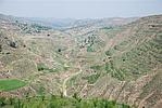
采集标本的概况性介绍:本段山险经过的刘坪堡可以采集到大量的瓦片遗物,瓦片纹饰为外饰绳纹,内饰麻点纹、布纹、素面的板筒瓦、瓦当残片、生活器皿残片。红光山险起自GPS043点,止于GPS045点,全长5800米,保存一般。本段山险以虎家后沟及其东岸台地山体为主要屏障,主体由北向南延伸,从虎家后沟沟口与安川河交汇处起,止于石咀山山咀,是利用了山险与河险相结合的特点作为天然防御屏障。在红光山险经过较为平坦的塌山南岸的坡面时,内侧有一处疑为堡址的遗址。GPS045点既是红光山险的止点,也是赵渠山险的起点。
现状:
Type:山险 Precipitous mountain areas
Protection Level:
Content:
Memo:
Other Records:
Distribution:
visit location in Tianditu Map[recommend] Distribution:
visit location in Tencent QQ Map Distribution:
visit location in Google MapDistribution:
visit location in Baidu MapNational ID:621027382106020008
Action:[
 Save in Data Basket
 ]
Picture:
Click the thumbnail to view the Big Pic. Click the Big Pic to Hide the Big Pic![Caption:红光山险
loading images --Please wait...]()
![Caption:红光山险
loading images --Please wait...]()
![Caption:红光山险
loading images --Please wait...]() Photo Links
Photo Links:
 Search ::
  Favorite/My Favorite :: Recent Changes :: :: Login