Official Name:
船舱峪长城36段ChuanCangYuChangCheng36DuanOur Name:
/
Other Name:
/
Period:明 / Ming Dynasty 1368~1644
Location: 天津市,天津市,蓟县,下营镇船仓峪长城35段城墙止点 / TianJinShi,TianJinShi,JiXian,XiaYingZhenChuanCangYuChangCheng35DuanChengQiangZhiDian
[
Looking Local List]
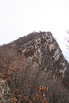
Details:长城类别:墙体
起点经纬高度:东经:117° 30′ 北纬:40° 12′ 海拔:860
终点经纬高度:东经:117° 30′ 北纬:40° 12′ 海拔:818
墙体走向:此段山险自船舱峪35段城墙止点,顺山势,至37段城墙起点,走向为东北至西南走向。
墙体类别:山险
结构特点及构筑方式:利用自然陡峭的崖体而形成的山险,看不出人为加工修整的痕迹。
此段山险基本保持原貌,全长348米。按特征点可分为3小段:
1、起点坐标:117°30′55.20″E,40°12′23.22″N,海拔860米,止点坐标:117°30′54.42″E,40°12′24.48″N,海拔875米。
此小段长45米,有明显小路。止点向西北下折。
2、起点坐标:117°30′54.42″E,40°12′24.48″N,海拔875米,止点坐标:117°30′43.32″E,40°12′24.00″N,海拔831米。
此小段长270米,有明显小路。止点向西南下折。
3、起点坐标:117°30′43.32″E,40°12′24.00″N,海拔831米,止点坐标:117°30′42.06″E,40°12′23.58″N,海拔818米。
此小段长33米,有明显小路。
现状:此段长城为山险。
Type:山险 Precipitous mountain areas
Protection Level:省保
Content:
Memo:
Other Records:
Distribution:
visit location in Tianditu Map[recommend] Distribution:
visit location in Tencent QQ Map Distribution:
visit location in Google MapDistribution:
visit location in Baidu MapNational ID:120225382106170075
Action:[
 Save in Data Basket
 ]
Picture:
Click the thumbnail to view the Big Pic. Click the Big Pic to Hide the Big Pic![Caption:船舱峪长城36段
loading images --Please wait...]() Photo Links
Photo Links:
 Search ::
  Favorite/My Favorite :: Recent Changes :: :: Login