Official Name:
ЙХЧПгјГЄГЧЖўЕРБп1ЖЮGuQiangYuChangChengErDaoBian1DuanOur Name:
/
Other Name:
/
Period:Уї / Ming Dynasty 1368~1644
Location: ЬьНђЪа,ЬьНђЪа,МЛЯи,ЯТгЊеђЙХЧПгјГЄГЧ6КХЕаЬЈЖЋФЯдМ60Уз / TianJinShi,TianJinShi,JiXian,XiaYingZhenGuQiangYuChangCheng6HaoDiTaiDongNanYue60Mi
ЁЁ[
Looking Local List]
Details:ГЄГЧРрБ№ЃКЧНЬх
Ц№ЕуОЮГИпЖШЃКЖЋОЃК117Ёу 32Ёф ББЮГЃК40Ёу 10Ёф КЃАЮЃК423
жеЕуОЮГИпЖШЃКЖЋОЃК117Ёу 32Ёф ББЮГЃК40Ёу 10Ёф КЃАЮЃК425
ЧНЬхзпЯђЃКДЫЖЮГЄГЧЧНЬхзпЯђЮЊЖЋББжСЮїФЯзпЯђЁЃ
ЧНЬхРрБ№ЃКЪЏЧН
НсЙЙЬиЕуМАЙЙжўЗНЪНЃКИУЖЮГЄГЧВЩгУЪЏПщИЩРнЖјГЩЁЃ
РнЦіЗНЗЈЃК
ГЧЧНЧНЬхОљЮЊЪЏПщИЩРнЖјГЩЃЌСНВргУДѓЪЏПщЕЅВуРнЦіЃЌжаМфЬювдаЁЪЏПщЁЃ
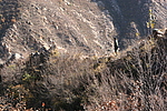
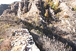
ЯжзДЃКДЫЖЮГЄГЧЮЊЪЏЧНЁЃДЫЖЮГЄГЧЧНЬхЮЛгкЙХЧПгј6КХЕаЬЈЖЋФЯдМ60УзЃЌЦфНЈСЂдкздШЛЩНЬхЩЯЃЌЛљДЁЮДМгаоећЃЌетЖЮЧНЬхаоЕУБШНЯЬиБ№ЃКЦфЮЛгкСљКХЕаЬЈЖЋФЯЕФвЛДІЩНМЙЩЯЃЌЮїгы6КХЕаЬЈФЯВрвЛДІЩНМЙЯрСЌЃЌЖЋЁЂФЯЁЂББШ§УцСйаќбТЃЌЖЋВППЩИЉюЋЬЋЦНЙЕЕзЁЃЦфВЛгыГЄГЧжїЯпЧНЬхЯрСЌЁЃ
ДЫЖЮЧНЬхЩЯВППэ1.17УзЃЌЦЪУцГЪОиаЮЃЌЩЯЯТЕШПэЃЌЧНЬхФЯВрОрЕиБэ1.00-0.7УзЃЌЧНЬхББВрОрЕиБэ0.8-0.93УзЃЌПДВЛГіЖтПкЕФКлМЃЃЌЧНЬхФЯВржаВПгавЛЖЮ4.7УзЯђФЯЕЙЫњЁЃ
ДЫЖЮЧНЬхећЬхБЃДцНЯВюЃЌШЋГЄ11.7УзЁЃ
Ц№ЕузјБъЃКЖЋОЃК117Ёу32Ёф12.06ЁхББЮГЃК40Ёу10Ёф54.12ЁхИпГЬЃК423УзЁЃ
жЙЕузјБъЃКЖЋОЃК117Ёу32Ёф11.52ЁхББЮГЃК40Ёу10Ёф54.00ЁхИпГЬЃК425УзЁЃ
Type:ЪЏЧН Stone wall
Protection Level:ЪЁБЃ
ЁЁ
Content:
Memo:
Other Records:
Distribution:
visit location in Tianditu Map[recommend] Distribution:
visit location in Tencent QQ Map Distribution:
visit location in Google MapDistribution:
visit location in Baidu MapNational ID:120225382102170038
Action:[
 Save in Data Basket
 ]
Picture:
Click the thumbnail to view the Big Pic. Click the Big Pic to Hide the Big Pic![Caption:ЙХЧПгјГЄГЧЖўЕРБп1ЖЮ
loading images --Please wait...]()
![Caption:ЙХЧПгјГЄГЧЖўЕРБп1ЖЮ
loading images --Please wait...]() Photo Links
Photo Links:
ЁЁ Search ::
  Favorite/My Favorite :: Recent Changes :: :: Login