Official Name:
靠边屯长城KaoBianTunChangChengOur Name:
/
Other Name:
/
Period:明 / Ming Dynasty 1368~1644
Location: 阜新市,清河门区,起点:乌龙坝镇靠边屯村(东北1000米处耕地上)止点:乌龙坝镇靠边屯村(西北400米处耕地上) / FuXinShi,QingHeMenQu,QiDianWuLongBaZhenKaoBianTunCun(DongBei1000MiChuGengDiShang)ZhiDianWuLongBaZhenKaoBianTunCun(XiBei400MiChuGengDiShang)
[
Looking Local List]
Details:长城类别:墙体
起点经纬高度:东经:121° 31′ 北纬:41° 45′ 海拔:87
终点经纬高度:东经:121° 29′ 北纬:41° 45′ 海拔:84
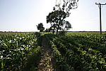
墙体走向:墙体大体呈东北-西南走向。该段长城土墙起自乌龙坝镇靠边屯村(东北1000米处耕地上)一路自东北向西南呈下行走势,止于乌龙坝镇靠边屯村(西北400米处耕地上)。
墙体类别:土墙
结构特点及构筑方式:剖面呈梯形。该段墙体基础为人工基础,墙身用黄土夯筑,墙体设施无存,夯土层大约厚0.1米~0.13米,底宽6米~12米,上宽2米~6米,现存高度0.6米~3米。
现状:土墙。
Type:土墙 Rammed earth wall
Protection Level:无
Content:
Memo:
Other Records:
Distribution:
visit location in Tianditu Map[recommend] Distribution:
visit location in Tencent QQ Map Distribution:
visit location in Google MapDistribution:
visit location in Baidu MapNational ID:210905382101170001
Action:[
 Save in Data Basket
 ]
Picture:
Click the thumbnail to view the Big Pic. Click the Big Pic to Hide the Big Pic![Caption:靠边屯长城
loading images --Please wait...]()
![Caption:靠边屯长城
loading images --Please wait...]() Photo Links
Photo Links:
 Search ::
  Favorite/My Favorite :: Recent Changes :: :: Login