Official Name:
七台子路河QiTaiZiLuHeOur Name:
/
Other Name:
/
Period:明 / Ming Dynasty 1368~1644
Location: 锦州市,黑山县,起点:大虎山镇七台子村(西南200米)止点:大虎山镇五台子村(南500米) / JinZhouShi,HeiShanXian,QiDianDaHuShanZhenQiTaiZiCun(XiNan200Mi)ZhiDianDaHuShanZhenWuTaiZiCun(Nan500Mi)
[
Looking Local List]
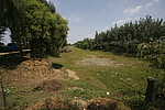
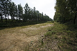
Details:长城类别:墙体
起点经纬高度:东经:122° 11′ 北纬:41° 32′ 海拔:16
终点经纬高度:东经:122° 11′ 北纬:41° 34′ 海拔:21
墙体走向:路河大体呈西南-东北走向。该段路河起自大虎山镇七台子村(西南200米),路河西南向东北呈上行走势,止于大虎山镇五台子村(南500米)处。
墙体类别:河险
结构特点及构筑方式:无。该段路河两侧河堤为黄土夯筑。内侧河堤宽4米~6米,外侧河堤宽5米~8米,现存高度0.5米~1米,河床宽8米~10米,顶宽16米,深2米~2.5米,内外侧河堤间距30米。
现状:土筑。
Type:河险 Precipitous river
Protection Level:无
Content:
Memo:
Other Records:
Distribution:
visit location in Tianditu Map[recommend] Distribution:
visit location in Tencent QQ Map Distribution:
visit location in Google MapDistribution:
visit location in Baidu MapNational ID:210726382107170004
Action:[
 Save in Data Basket
 ]
Picture:
Click the thumbnail to view the Big Pic. Click the Big Pic to Hide the Big Pic![Caption:七台子路河
loading images --Please wait...]()
![Caption:七台子路河
loading images --Please wait...]() Photo Links
Photo Links:
 Search ::
  Favorite/My Favorite :: Recent Changes :: :: Login