Welcome you Visit www.thegreatwall.com.cn!!     Location:EN Version->The Great Wall Architecture and Geographical Information Database[ Login ]/[ Register ]  
 Home :: Regional Index :: List :: Search :: My Data Basket :: Favorite/My Favorite :: Recent Changes :: :: Login
Official Name:泉头长城
QuanTouChangCheng
Our Name: /
Other Name: /
Period:明 / Ming Dynasty 1368~1644
Location: 铁岭市,昌图县,起点:泉头镇石虎子村孙家窑屯西北200米的高台庙山顶(泉头长城敌台)止点:沈哈高速公路东侧墙体断点 / TieLingShi,ChangTuXian,QiDianQuanTouZhenShiHuZiCunSunJiaYaoTunXiBei200MiDeGaoTaiMiaoShanDing(QuanTouChangChengDiTai)ZhiDianShenHaGaoSuGongLuDongCeQiangTiDuanDian
         [Looking Local List]
Details:长城类别:墙体 起点经纬高度:东经:124° 11′ 北纬:42° 51′ 海拔:272 终点经纬高度:东经:124° 11′ 北纬:42° 51′ 海拔:183 墙体走向:此段墙体起于泉头长城敌台,止于沈哈高速公路,整体为东南-西北走向。 墙体类别:土墙 结构特点及构筑方式:上小下大的梯形。 采集标本的概括性说明:无。该段墙体顶宽1.2~1.4米,底宽4.5~5.3米,存高1~1.3米。 现状:土墙。
Type:土墙 Rammed earth wall
Protection Level:无  
Content:
Memo:
Other Records:
Distribution:visit location in Tianditu Map[recommend]
Distribution:visit location in Tencent QQ Map
Distribution:visit location in Google Map
Distribution:visit location in Baidu Map
National ID:211224382101170008
Action:[ Save in Data Basket ]
Picture: Click the thumbnail to view the Big Pic. Click the Big Pic to Hide the Big Pic
泉头长城     
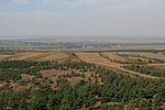
Caption:泉头长城
Photo Time:2007-10-02 11:55:08
Photo Contributor:辽宁省文物局
[Open in New Window]  
Caption:泉头长城
loading images --Please wait...
泉头长城     
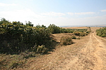
Caption:泉头长城
Photo Time:2007-10-02 12:05:52
Photo Contributor:辽宁省文物局
[Open in New Window]  
Caption:泉头长城
loading images --Please wait...
泉头长城     
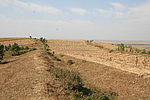
Caption:泉头长城
Photo Time:2007-10-02 12:09:24
Photo Contributor:辽宁省文物局
[Open in New Window]  
Caption:泉头长城
loading images --Please wait...
泉头长城     
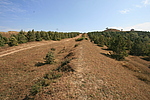
Caption:泉头长城
Photo Time:2007-10-02 12:09:33
Photo Contributor:辽宁省文物局
[Open in New Window]  
Caption:泉头长城
loading images --Please wait...
Photo Links:

 the Page History :: Edit Photo :: Manager Area: Confirm :: Restore :: Delete
 评论/讨论/留言区 :: 发表新帖 :: 刷新 :: 回到顶部
 留言总数0帖 页次:1/0 每页:20条 
v0.1 2003; v1.3 2022.05 ; © 2003~2022,www.thegreatwall.com.cn