Official Name:
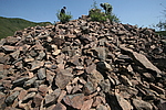
下霍家沟西山长城3号敌台XiaHuoJiaGouXiShanChangCheng3HaoDiTaiOur Name:
/
Other Name:
/
Period:明 / Ming Dynasty 1368~1644
Location: 葫芦岛市,绥中县,永安乡塔子沟村康家房子屯砂山上 / HuLuDaoShi,SuiZhongXian,YongAnXiangTaZiGouCunKangJiaFangZiTunShaShanShang
[
Looking Local List]
Details:长城类别:单体建筑
经纬高度:东经:119° 54′ 北纬:40° 15′ 海拔:265
建筑形式:该敌台坐落在前卫镇背陈荫嶂村下霍家沟屯西北的山上,位于下霍家沟西山长城2段墙体上,海拔高度为337米。根据现场调查判断该敌台为自然沉积岩石基础,台体坍塌后有大量的毛石堆积,断定该台体应为石头结构,其外侧是用不规则的大块毛石包砌,内用碎石和山皮土填充而成。因台体坍塌严重,台体的建筑形制已经无法查清。其他的设施无存。
材料:台体为石结构,石质以混合花岗石为主。
附近遗存:该位于下霍家沟西山长城2段墙体上。东430米为下霍家沟西山长城2号敌台,西南820米为康家房子蚂蚱沟长城敌台,南400米是康家房子后山烽火台。东南3100米是背荫嶂堡城。
Type:敌台 Defence Tower
Protection Level:无
Content:
Memo:
Other Records:
Distribution:
visit location in Tianditu Map[recommend] Distribution:
visit location in Tencent QQ Map Distribution:
visit location in Google MapDistribution:
visit location in Baidu MapNational ID:211421352101170085
Action:[
 Save in Data Basket
 ]
Picture:
Click the thumbnail to view the Big Pic. Click the Big Pic to Hide the Big Pic![Caption:下霍家沟西山长城3号敌台
loading images --Please wait...]() Photo Links
Photo Links:
 Search ::
  Favorite/My Favorite :: Recent Changes :: :: Login