Official Name:
张家边壕明长城ZhangJiaBianHaoMingChangChengOur Name:
/
Other Name:
/
Period:明 / Sui Dynasty 581~618
Location: 宁夏回族自治区,吴忠市,盐池县,高沙窝镇毛卜剌古城西北1.75千米--高沙窝镇张家边壕西北2.6千米 / NingXiaHuiZuZiZhiQu,WuZhongShi,YanChiXian,GaoShaWoZhenMaoBoGuChengXiBei175QianMiGaoShaWoZhenZhangJiaBianHaoXiBei26QianMi
[
Looking Local List]
Details:长城类别:墙体
起点经纬高度:东经:106° 51′ 北纬:38° 09′ 海拔:1365
终点经纬高度:东经:106° 49′ 北纬:38° 09′ 海拔:1368
墙体走向:
墙体类别:土墙
结构特点及构筑方式:无。不清。
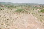
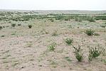
现状:此段长城由东南-西北向延伸,至张家边壕西北地界GPS0773点处与灵武市交界。东段地表墙体被大面积沙草覆盖,痕迹不甚明显,西段墙体痕迹时断时续,整体保存状况差。按其走向及保存现状分为2段:
第一段:GPS0756--GPS0758点,长1450米。保存状况差。
第二段:GPS0758--GPS0773点,长830米。保存状况差。
损坏情况及原因:
此段长城整体保存差。其损害有自然与人为两种,以自然因素为主。
自然因素主要有:风蚀雨淋、大片沙地掩埋。
人为因素主要有:修路、建厂。
Type:土墙 Rammed earth wall
Protection Level:无
Content:
Memo:
Other Records:
Distribution:
visit location in Tianditu Map[recommend] Distribution:
visit location in Tencent QQ Map Distribution:
visit location in Google MapDistribution:
visit location in Baidu MapNational ID:640323382101110022
Action:[
 Save in Data Basket
 ]
Picture:
Click the thumbnail to view the Big Pic. Click the Big Pic to Hide the Big Pic![Caption:张家边壕明长城
loading images --Please wait...]()
![Caption:张家边壕明长城
loading images --Please wait...]() Photo Links
Photo Links:
 Search ::
  Favorite/My Favorite :: Recent Changes :: :: Login