Official Name:
ЧхЫЎгЊДхЫхГЄГЧ4ЖЮQingShuiYingCunSuiChangCheng4DuanOur Name:
/
Other Name:
/
Period:Уї / Sui Dynasty 581~618
Location: ФўЯФЛизхзджЮЧј,вјДЈЪа,СщЮфЪа,ТэМвЬВеђЧхЫЎгЊДхЖўзщЮїББ2.4ЧЇУз--ТэМвЬВеђЧхЫЎгЊДхЖўзщЮїББ4.6ЧЇУз / NingXiaHuiZuZiZhiQu,YinChuanShi,LingWuShi,MaJiaTanZhenQingShuiYingCunErZuXiBei24QianMiMaJiaTanZhenQingShuiYingCunErZuXiBei46QianMi
ЁЁ[
Looking Local List]
Details:ГЄГЧРрБ№ЃКЧНЬх
Ц№ЕуОЮГИпЖШЃКЖЋОЃК106Ёу 45Ёф ББЮГЃК38Ёу 10Ёф КЃАЮЃК1345
жеЕуОЮГИпЖШЃКЖЋОЃК106Ёу 44Ёф ББЮГЃК38Ёу 11Ёф КЃАЮЃК1314
ЧНЬхзпЯђЃК
ЧНЬхРрБ№ЃКЭСЧН
НсЙЙЬиЕуМАЙЙжўЗНЪНЃКЮоЁЃВЛЧхЁЃ
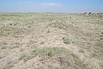
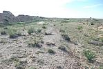
ЯжзДЃКДЫЖЮГЄГЧгЩЖЋФЯ-ЮїББЯђбгЩьЃЌЧНЬхЖЋЖЮЕиБэЮоКлМЃЃЌдгаГЄГЧТЗЯпБЛбгУрВЛЖЯЕиЛЦЩГЭСИВИЧЃЌЦфЩЯГЄТњдгВнЃЛЧНЬхЮїЖЮвђЫЎЭССїЪЇМАЩНКщСЌФъГхЫЂЃЌЯжвбЬЎЫњБРЛйШыЧхЫЎКгЕРЁЃгЩДЫЕМжТЧНЬхећЬхЯћЪЇЁЃАДЦфзпЯђМАБЃДцЯжзДЗжЮЊ1ЖЮЃК
ЕквЛЖЮЃКGPS0796--GPS0797ЕуЃЌГЄ1880УзЁЃБЃДцзДПіЯћЪЇЁЃ
Ы№ЛЕЧщПіМАдвђЃК
ДЫЖЮГЄГЧећЬхБЃДцВюЁЃЦфЫ№КІгаздШЛгыШЫЮЊСНжжЃЌвдздШЛвђЫиЮЊжїЁЃ
здШЛвђЫижївЊгаЃКЗчЪДгъСмЁЂДѓЦЌЩГЕибкТёЁЃ
Type:ЭСЧН Rammed earth wall
Protection Level:ЪЁБЃ
ЁЁ
Content:
Memo:
Other Records:
Distribution:
visit location in Tianditu Map[recommend] Distribution:
visit location in Tencent QQ Map Distribution:
visit location in Google MapDistribution:
visit location in Baidu MapNational ID:640181382101110004
Action:[
 Save in Data Basket
 ]
Picture:
Click the thumbnail to view the Big Pic. Click the Big Pic to Hide the Big Pic![Caption:ЧхЫЎгЊДхЫхГЄГЧ4ЖЮ
loading images --Please wait...]()
![Caption:ЧхЫЎгЊДхЫхГЄГЧ4ЖЮ
loading images --Please wait...]() Photo Links
Photo Links:
ЁЁ Search ::
  Favorite/My Favorite :: Recent Changes :: :: Login