Official Name:
南长滩夹巴沟1段长城NanChangTanJiaBaGou1DuanChangChengOur Name:
边墙 / BianQiang
Other Name:
/
Period:明 / Ming Dynasty 1368~1644
Location: 宁夏回族自治区,中卫市,沙坡头区,迎水桥镇南长滩村西南夹巴沟GPS0541——迎水桥镇南长滩村西南夹巴沟西GPS0543 / NingXiaHuiZuZiZhiQu,ZhongWeiShi,ShaPoTouQu,YingShuiQiaoZhenNanChangTanCunXiNanJiaBaGouGPS0541YingShuiQiaoZhenNanChangTanCunXiNanJiaBaGouXiGPS0543
[
Looking Local List]
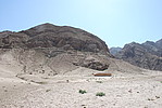
Details:长城类别:墙体
起点经纬高度:东经:104° 37′ 北纬:37° 16′ 海拔:1361
终点经纬高度:东经:104° 36′ 北纬:37° 16′ 海拔:1306
墙体走向:
墙体类别:山险墙
结构特点及构筑方式:该段墙体基础为自然基础,墙体以山险墙为主,墙高10米-22米。
构筑方法:
削山为险。
现状:该段墙体长1273米,按照保存情况分为二段:
第一段:GPS0541-GPS0542,长821米,山险墙。山险墙沿缸子沟北缘向西南延伸至蝙蝠嘴子山。将山体削为陡峭的壁面作为防御体系。人为加工痕迹明显,高10米-22米。
第二段:GPS0542-GPS0543,长452米,山险墙。山险墙沿蝙蝠嘴子山北缘向西延伸至沙湾沟。将山体削为陡峭的壁面作为防御体系。人为加工痕迹明显,高10米-15米。
Type:山险墙 Precipitous mountain areas as wall
Protection Level:省保
Content:
Memo:
Other Records:
Distribution:
visit location in Tianditu Map[recommend] Distribution:
visit location in Tencent QQ Map Distribution:
visit location in Google MapDistribution:
visit location in Baidu MapNational ID:640502382105170065
Action:[
 Save in Data Basket
 ]
Picture:
Click the thumbnail to view the Big Pic. Click the Big Pic to Hide the Big Pic![Caption:南长滩夹巴沟1段长城
loading images --Please wait...]()
![Caption:南长滩夹巴沟1段长城
loading images --Please wait...]() Photo Links
Photo Links:
 Search ::
  Favorite/My Favorite :: Recent Changes :: :: Login