Official Name:
和平村段土墙HePingCunDuanTuQiangOur Name:
旧北长城 / JiuBeiChangCheng
Other Name:
/
Period:明 / Ming Dynasty 1368~1644
Location: 宁夏回族自治区,石嘴山市,惠农区,尾闸镇和平村G109国道东侧――红果子镇小墩湾110国道以西5米处 / NingXiaHuiZuZiZhiQu,ShiZuiShanShi,HuiNongQu,WeiZhaZhenHePingCunG109GuoDaoDongCeHongGuoZiZhenXiaoDunWan110GuoDaoYiXi5MiChu
[
Looking Local List]
Details:长城类别:墙体
起点经纬高度:东经:106° 45′ 北纬:39° 10′ 海拔:1090
终点经纬高度:东经:106° 40′ 北纬:39° 10′ 海拔:1093
墙体走向:此段墙体东起惠农区尾闸镇和平村,西至红果子镇小墩湾今109国道以西5米处的残存土墙起点,全长约6400米。大致呈东南-西北向,方向85度左右。
墙体类别:消失的长城
结构特点及构筑方式:无。无。
现状:土墙。(?)
Type:消失的长城 Disappeared wall
Protection Level:省保
Content:
Memo:
Other Records:
Distribution:
visit location in Tianditu Map[recommend] Distribution:
visit location in Tencent QQ Map Distribution:
visit location in Google MapDistribution:
visit location in Baidu MapNational ID:640205382301170002
Action:[
 Save in Data Basket
 ]
Picture:
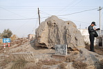
Click the thumbnail to view the Big Pic. Click the Big Pic to Hide the Big Pic![Caption:和平村段土墙
loading images --Please wait...]() Photo Links
Photo Links:
 Search ::
  Favorite/My Favorite :: Recent Changes :: :: Login