Official Name:
·Ε’Ή”ΆΝ«ΫShiDunZiTuQiangOur Name:
≥«ΈςΡœ«Ϋ / ChengXiNanQiang
Other Name:
/
Period:Ος / Ming Dynasty 1368~1644
Location: ΡΰœΡΜΊΉεΉ‘÷Έ«χ, ·Ήλ…Ϋ –,ΤΫ¬όœΊ,Κλ―¬Ή”œγΆθΦ“ΙΒΕΪΡœ7.5«ßΟΉΓΣΓΣΚλ―¬Ή”œγΆθΦ“ΙΒΕΪ±±7.6«ßΟΉ / NingXiaHuiZuZiZhiQu,ShiZuiShanShi,PingLuoXian,HongYaZiXiangWangJiaGouDongNan75QianMiHongYaZiXiangWangJiaGouDongBei76QianMi
ΓΓ[
Looking Local List]
Details:≥Λ≥«άύ±πΘΚ«ΫΧε
ΤπΒψΨ≠Έ≥ΗΏΕ»ΘΚΕΪΨ≠ΘΚ106Γψ 58Γδ ±±Έ≥ΘΚ39Γψ 1Γδ ΚΘΑΈΘΚ1164
÷’ΒψΨ≠Έ≥ΗΏΕ»ΘΚΕΪΨ≠ΘΚ106Γψ 58Γδ ±±Έ≥ΘΚ39Γψ 1Γδ ΚΘΑΈΘΚ1161
«ΫΧεΉΏœρΘΚΗΟΕΈ«ΫΧεΤπΒψΈΜ”ΎΆθΦ“ΙΒΕΪ7.5ΙΪάοΘ§¥σ÷¬≥ Ρœ±±ΉΏœρΓΘ
«ΫΧεάύ±πΘΚΆΝ«Ϋ
ΫαΙΙΧΊΒψΦΑΙΙ÷ΰΖΫ ΫΘΚΈόΓΘ
≤…Φ·±ξ±ΨΫι…ήΘΚ
ΈόΓΘ
œ÷Ή¥ΘΚ«ΫΧε”ΟΜΤπΛΆΝΚΜ÷ΰΕχ≥…,Τδ÷–Φ–‘””––Γ ·Τ§ΓΘΗΟΕΈ«ΫΧεΈΜ”ΎΤΫ¬όœΊΚλ―¬Ή”œγΆθΦ“ΙΒ¥εΕΪ7.5«ßΟΉΓΘΧ’ά÷≥ΛΒΧ«ΫΧε≤–¥φ≥ΛΕ»ΈΣ331ΟΉΘ§±Θ¥φ≥ΧΕ»≤νΘ§Τδ”ύ«ΫΧε“―≤ΜΩ…ΦϊΓΘ
ΤπΒψΉχ±ξΈΣGPS0488ΒψΘΚΕΪΨ≠ΘΚ106Γψ58Γδ03.50Γε±±Έ≥ΘΚ39Γψ01Γδ35.00ΓεΗΏ≥ΧΘΚ1164ΟΉΓΘ
÷ΙΒψΉχ±ξΈΣGPS0487ΒψΘΚΕΪΨ≠ΘΚ106Γψ58Γδ03.60Γε±±Έ≥ΘΚ39Γψ01Γδ23.60ΓεΗΏ≥ΧΘΚ1161ΟΉΓΘ
·Ε’Ή”≥Λ≥«ΕΈ»Ϊ≥Λ331ΟΉ,”ΟΡύΆΝΥι ·ΩιΕ―÷ΰΚΜ¥ρΕχ≥…Θ§«ΫΧεΫ®‘ΎΡœ±±ΉΏœρΒΡ…≥ΝΚ…œΘ§ΆΙœ‘ΗΏ¥σΘ§–Έ»γΒΧΑ”Θ§“ρ¥Υ”–ΓΑ≥ΛΒΧΓ±÷°≥ΤΓΘ
Type:ΆΝ«Ϋ Rammed earth wall
Protection Level: Γ±Θ
ΓΓ
Content:
Memo:
Other Records:
Distribution:
visit location in Tianditu Map[recommend] Distribution:
visit location in Tencent QQ Map Distribution:
visit location in Google MapDistribution:
visit location in Baidu MapNational ID:640221382101170014
Action:[
 Save in Data Basket
 ]
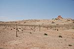
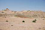
Picture:
Click the thumbnail to view the Big Pic. Click the Big Pic to Hide the Big Pic![Caption: ·Ε’Ή”ΆΝ«Ϋ
loading images --Please wait...]()
![Caption: ·Ε’Ή”ΆΝ«Ϋ
loading images --Please wait...]()
![Caption: ·Ε’Ή”ΆΝ«Ϋ
loading images --Please wait...]() Photo Links
Photo Links:
ΓΓ Search ::
  Favorite/My Favorite :: Recent Changes :: :: Login