Official Name:
兴隆镇西郊战国秦长城XingLongZhenXiJiaoZhanGuoQinChangChengOur Name:
/
Other Name:
/
Period:战国秦 / Warring States 475~221 B.C.
Location: 宁夏回族自治区,固原市,西吉县,将台乡朱家堡子村西南1千米葫芦河东岸――兴隆镇王家河村东南1.5千米葫芦河东岸王家河村敌台 / NingXiaHuiZuZiZhiQu,GuYuanShi,XiJiXian,JiangTaiXiangZhuJiaBaoZiCunXiNan1QianMiHuLuHeDongAnXingLongZhenWangJiaHeCunDongNan15QianMiHuLuHeDongAnWangJiaHeCunDiTai
[
Looking Local List]
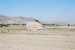
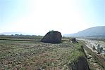
Details:长城类别:墙体
起点经纬高度:东经:105° 47′ 北纬:35° 44′ 海拔:1713
终点经纬高度:东经:105° 48′ 北纬:35° 41′ 海拔:1727
墙体走向:
墙体类别:土墙
结构特点及构筑方式:无。不清。
现状:此段墙体沿葫芦河东岸由北向南延伸,其间墙体因葫芦河河水泛滥、河床改道以及平田整地使墙体消失无存,仅在止点处尚存一处保存状况较差的敌台。该段所处地势较平缓,落差不大,按其走向及保存现状分为1段:
第一段:GPSA542-GPSA543点,长4660米,消失。
损坏情况及原因:
此段墙体整体已消失。其损害有自然与人为两种。
自然因素主要有:
山洪雨水侵蚀、水土流失
葫芦河河水泛滥及河道改道,造成墙体崩塌。
人为因素主要有:
居民生产生活破坏,该段沿线居民修路、建房、平整田地对墙体造成严重破坏。
Type:土墙 Rammed earth wall
Protection Level:国保
Content:
Memo:
Other Records:
Distribution:
visit location in Tianditu Map[recommend] Distribution:
visit location in Tencent QQ Map Distribution:
visit location in Google MapDistribution:
visit location in Baidu MapNational ID:640422382101020015
Action:[
 Save in Data Basket
 ]
Picture:
Click the thumbnail to view the Big Pic. Click the Big Pic to Hide the Big Pic![Caption:兴隆镇西郊战国秦长城
loading images --Please wait...]()
![Caption:兴隆镇西郊战国秦长城
loading images --Please wait...]() Photo Links
Photo Links:
 Search ::
  Favorite/My Favorite :: Recent Changes :: :: Login