Official Name:
ЖЋЙЕФдДхеНЙњЧиГЄГЧDongGouNaoCunZhanGuoQinChangChengOur Name:
/
Other Name:
/
Period:еНЙњЧи / Warring States 475~221 B.C.
Location: ФўЯФЛизхзджЮЧј,ЙЬдЪа,джнЧј,еХвзеђЪЏзьДхЖЋЙЕФдздШЛДхББЁЊЁЊеХвзеђЪЏзьДхЖЋЙЕФдздШЛДхФЯ / NingXiaHuiZuZiZhiQu,GuYuanShi,YuanZhouQu,ZhangYiZhenShiZuiCunDongGouNaoZiRanCunBeiZhangYiZhenShiZuiCunDongGouNaoZiRanCunNan
ЁЁ[
Looking Local List]
Details:ГЄГЧРрБ№ЃКЧНЬх
Ц№ЕуОЮГИпЖШЃКЖЋОЃК106Ёу 04Ёф ББЮГЃК35Ёу 50Ёф КЃАЮЃК2289
жеЕуОЮГИпЖШЃКЖЋОЃК106Ёу 03Ёф ББЮГЃК35Ёу 49Ёф КЃАЮЃК2215
ЧНЬхзпЯђЃК
ЧНЬхРрБ№ЃКЭСЧН
НсЙЙЬиЕуМАЙЙжўЗНЪНЃКЮоЁЃВЛЧхЁЃ
ЯжзДЃКДЫЖЮЧНЬхгЩЖЋББЯђЮїФЯбгЩьЃЌЕиЪЦГЪЖЋББИпЮїФЯЕЭЃЌТфВюНЯДѓЃЌАДЦфзпЯђМАБЃДцЯжзДЗжЮЊ4ЖЮЃК
ЕквЛЖЮЃКGPSA425--GPSA426ЕуЃЌГЄ988УзЃЌЯћЪЇЃЛ
ЕкЖўЖЮЃКGPSA426--GPSA427ЕуЃЌГЄ228УзЃЌЯћЪЇЃЛ
ЕкШ§ЖЮЃКGPSA427--GPSA428ЕуЃЌГЄ776УзЃЌЯћЪЇЃЛ
ЕкЫФЖЮЃКGPSA428--GPSA429ЕуЃЌГЄ386УзЃЌЯћЪЇЁЃ
Ы№ЛЕЧщПіМАдвђЃК
ДЫЖЮЧНЬхећЬхвбЯћЪЇЁЃЦфЫ№КІгаздШЛгыШЫЮЊСНжжЁЃ
здШЛвђЫижївЊгаЃК
гъЫЎГЃФъЕФЧжЪДКЭЩНКщГхЫЂЖдЧНЬхдьГЩКмДѓЕФЦЦЛЕЁЃ
ШЫЮЊвђЫижївЊгаЃК
ОгУёЩњВњЩњЛюЦЦЛЕЃЌИУЖЮЧНЬхжївЊЛйгкбиЯпОгУёЦНећЬяЕиЁЃ
Type:ЭСЧН Rammed earth wall
Protection Level:ЙњБЃ
ЁЁ
Content:
Memo:
Other Records:
Distribution:
visit location in Tianditu Map[recommend] Distribution:
visit location in Tencent QQ Map Distribution:
visit location in Google MapDistribution:
visit location in Baidu MapNational ID:640402382101020053
Action:[
 Save in Data Basket
 ]
Picture:
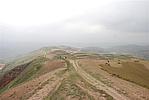
Click the thumbnail to view the Big Pic. Click the Big Pic to Hide the Big Pic![Caption:ЖЋЙЕФдДхеНЙњЧиГЄГЧ
loading images --Please wait...]()
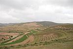
![Caption:ЖЋЙЕФдДхеНЙњЧиГЄГЧ
loading images --Please wait...]() Photo Links
Photo Links:
ЁЁ Search ::
  Favorite/My Favorite :: Recent Changes :: :: Login