Official Name:
沙窝沟战国秦长城ShaWoGouZhanGuoQinChangChengOur Name:
/
Other Name:
/
Period:战国秦 / Warring States 475~221 B.C.
Location: 宁夏回族自治区,固原市,原州区,清河镇水泉村糜地湾自然村西――清河镇沙窝村沙窝沟口北侧 / NingXiaHuiZuZiZhiQu,GuYuanShi,YuanZhouQu,QingHeZhenShuiQuanCunMiDiWanZiRanCunXiQingHeZhenShaWoCunShaWoGouKouBeiCe
[
Looking Local List]
Details:长城类别:墙体
起点经纬高度:东经:106° 19′ 北纬:36° 02′ 海拔:1813
终点经纬高度:东经:106° 18′ 北纬:36° 03′ 海拔:1701
墙体走向:
墙体类别:土墙
结构特点及构筑方式:无。黄土夯筑而成。
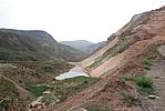
现状:此段长城沿沙窝沟东南侧山坡修建,由东南向西北延伸,地势东南高西北低,落差较大。由于山体滑坡,人工采砂等原因,墙体多半已消失无存。按其走向及保存现状分为3段:
第一段:GPS0364--GPS0365点,长304米,差;
第二段:GPS0365--GPS0366点,长377米,消失;
第三段:GPS0366--GPS0367点,长1620米,消失。
损坏情况及原因:
此段长城整体大部已消失。其损害有自然与人为两种,以自然因素为主。
自然因素主要有:
山体垮塌
此段墙体因山体塌垮而毁。
人为因素主要有:
采砂,修路,挖山。
该段墙体沿线设有多处采砂场,采砂、修路对墙体造成破坏。
Type:土墙 Rammed earth wall
Protection Level:国保
Content:
Memo:
Other Records:
Distribution:
visit location in Tianditu Map[recommend] Distribution:
visit location in Tencent QQ Map Distribution:
visit location in Google MapDistribution:
visit location in Baidu MapNational ID:640402382101020022
Action:[
 Save in Data Basket
 ]
Picture:
Click the thumbnail to view the Big Pic. Click the Big Pic to Hide the Big Pic![Caption:沙窝沟战国秦长城
loading images --Please wait...]()
![Caption:沙窝沟战国秦长城
loading images --Please wait...]()
![Caption:沙窝沟战国秦长城
loading images --Please wait...]() Photo Links
Photo Links:
 Search ::
  Favorite/My Favorite :: Recent Changes :: :: Login