Official Name:
茅山山险2段MaoShanShanXian2DuanOur Name:
/
Other Name:
/
Period:汉
/ Han Dynasty 206 B.C.~316A.D.
Location: 甘肃省,张掖市,山丹县,起点:清泉镇红寺湖村以南约2.5千米山顶止点:清泉镇红寺湖村西南约3.5千米山顶 / GanSuSheng,ZhangYeShi,ShanDanXian,QiDianQingQuanZhenHongSiHuCunYiNanYue25QianMiShanDingZhiDianQingQuanZhenHongSiHuCunXiNanYue35QianMiShanDing
[
Looking Local List]
Details:长城类别:墙体
起点经纬高度:东经:101° 06′ 北纬:38° 52′ 海拔:2289
终点经纬高度:东经:101° 05′ 北纬:38° 53′ 海拔:2246
墙体走向:
墙体类别:山险
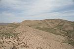
结构特点及构筑方式:山险位于山丹县城的北部,南隔走廊平原与祁连山相望,是走廊平原与蒙古高原的过度地带,一般海拔1600-3200米之间,相对高度800-1000米。山体呈带状分布,沿西北-东南向分布,属剥蚀中山,岩石裸露,山脊及阳坡物理风化强烈、岩石碎屑广布;起自第0147点,止于点第0148点,全长1362米,海拔在2289米-2246米之间,山势陡峻起伏,山顶尖峭,实地垂直高度约在50米-200米之间,南北两侧坡度在45°-70°之间,峰峦连绵,沟壑纵横,止点处山体西侧是90°的悬崖峭壁,汉代充分利用其险势作为一道天然防御屏障。
现状:
Type:山险 Precipitous mountain areas
Protection Level:
Content:
Memo:
Other Records:
Distribution:
visit location in Tianditu Map[recommend] Distribution:
visit location in Tencent QQ Map Distribution:
visit location in Google MapDistribution:
visit location in Baidu MapNational ID:620725382106040018
Action:[
 Save in Data Basket
 ]
Picture:
Click the thumbnail to view the Big Pic. Click the Big Pic to Hide the Big Pic![Caption:茅山山险2段
loading images --Please wait...]() Photo Links
Photo Links:
 Search ::
  Favorite/My Favorite :: Recent Changes :: :: Login