Official Name:
陡城山险DouChengShanXianOur Name:
/
Other Name:
/
Period:明
/ Ming Dynasty 1368~1644
Location: 甘肃省,白银市,平川区,起点:水泉镇陡城村李家沟社南1.5千米的边墙湾沟南侧止点:水泉镇牙沟水村月河社南300米的沙河西岸月河烽火台 / GanSuSheng,BaiYinShi,PingChuanQu,QiDianShuiQuanZhenDouChengCunLiJiaGouSheNan15QianMiDeBianQiangWanGouNanCeZhiDianShuiQuanZhenYaGouShuiCunYueHeSheNan300MiDeShaHeXiAnYueHeFengHuoTai
[
Looking Local List]
Details:长城类别:墙体
起点经纬高度:东经:104° 39′ 北纬:36° 44′ 海拔:1397
终点经纬高度:东经:104° 42′ 北纬:36° 42′ 海拔:1389
墙体走向:
墙体类别:山险
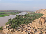
结构特点及构筑方式:山险位于黄河东北岸连绵不断的山梁之间,地势较为平缓,坡度一般在300-500之间。
该段山险起自第0059点,止于第0061点,全长5700米。山险起自边墙湾长城止点,沿连绵不断的山梁向东南延伸接陡城堡。自陡城堡向东南有黄庄、下牙沟水村,再向东南接连绵不断的山体,经虎头咀至月河烽火台。这段山险东北侧紧依绵延不断的山梁,西南侧毗邻黄河天险,黄河岸边山崖落差较大,一般在30米-50米之间。山崖陡峭难攀,与自然山体及黄河构成防御体系。
现状:
Type:山险 Precipitous mountain areas
Protection Level:
Content:
Memo:
Other Records:
Distribution:
visit location in Tianditu Map[recommend] Distribution:
visit location in Tencent QQ Map Distribution:
visit location in Google MapDistribution:
visit location in Baidu MapNational ID:620403382106170005
Action:[
 Save in Data Basket
 ]
Picture:
Click the thumbnail to view the Big Pic. Click the Big Pic to Hide the Big Pic![Caption:陡城山险
loading images --Please wait...]()
![Caption:陡城山险
loading images --Please wait...]() Photo Links
Photo Links:
 Search ::
  Favorite/My Favorite :: Recent Changes :: :: Login