Official Name:
暗壁支线长城AnBiZhiXianChangChengOur Name:
断臂长城 / DuanBiChangCheng
Other Name:
/
Period:明
/ Ming Dynasty 1368~1644
Location: 甘肃省,嘉峪关市,市区,起点:峪泉镇黄草营村1组西南300米处止点:峪泉镇黄草营村1组西南350米处 / GanSuSheng,JiaYuGuanShi,ShiQu,QiDianYuQuanZhenHuangCaoYingCun1ZuXiNan300MiChuZhiDianYuQuanZhenHuangCaoYingCun1ZuXiNan350MiChu
[
Looking Local List]
Details:长城类别:墙体
起点经纬高度:东经:098° 10′ 北纬:39° 50′ 海拔:1672
终点经纬高度:东经:098° 10′ 北纬:39° 50′ 海拔:1670
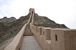
墙体走向:该段长城墙体沿石关峡口南侧山脊向山上延伸,总体为由东向西走向。
墙体类别及构筑方式:该段墙体为黄土版筑,土质以黄沙土和黄色胶土为主,夹杂有少量砂石,夯层厚0.13米-0.18米。
墙体类别:土墙
结构特点及构筑方式:无完整剖面。该段墙体基础为自然沉积沙石基础,版筑而成,墙体底宽、顶宽不详,高0.20米-0.40米。
该段长城起自第0164点,止于第0165点,保存差,仅残存高0.20米-0.40米的遗迹,残迹长293米。断续出现,其残迹上为嘉峪关市黄草营村农民杨永福于2002年重新修复建的的墙体。
现状:
Type:土墙 Rammed earth wall
Protection Level:
Content:
Memo:
Other Records:
Distribution:
visit location in Tianditu Map[recommend] Distribution:
visit location in Tencent QQ Map Distribution:
visit location in Google MapDistribution:
visit location in Baidu MapNational ID:620201382101170026
Action:[
 Save in Data Basket
 ]
Picture:
Click the thumbnail to view the Big Pic. Click the Big Pic to Hide the Big Pic![Caption:暗壁支线长城
loading images --Please wait...]() Photo Links
Photo Links:
 Search ::
  Favorite/My Favorite :: Recent Changes :: :: Login