Official Name:
野麻湾支线长城YeMaWanZhiXianChangChengOur Name:
边墙 / BianQiang
Other Name:
/
Period:明
/ Ming Dynasty 1368~1644
Location: 甘肃省,嘉峪关市,市区,起点:新城镇野麻湾村委会东南800米处野麻湾1号敌台西20米止点:新城镇野麻湾村2组南侧360米处 / GanSuSheng,JiaYuGuanShi,ShiQu,QiDianXinChengZhenYeMaWanCunWeiHuiDongNan800MiChuYeMaWan1HaoDiTaiXi20MiZhiDianXinChengZhenYeMaWanCun2ZuNanCe360MiChu
[
Looking Local List]
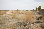
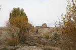
Details:长城类别:墙体
起点经纬高度:东经:098° 22′ 北纬:39° 55′ 海拔:1491
终点经纬高度:东经:098° 23′ 北纬:39° 55′ 海拔:1490
墙体走向:该段长城墙体总体为西南-东北走向。
墙体类别及构筑方式:该段墙体为黄土版筑,土质以黄沙土和黄色胶土、盐碱土为主,夹杂有少量砂石,夯层厚0.23米-0.25米。
墙体类别:土墙
结构特点及构筑方式:无完整剖面。该段墙体基础为自然沉淀砂石基础,黄沙土版筑而成,墙体底宽2.40米,顶宽0.80米,残高1.60米。
该段长城起自第0206点,止于第0207点,保存一般,全长325米。因受风蚀雨淋,墙体保存较矮,夯层明显,墙体底宽2.40米,顶宽0.80米,残高1.60米,夯层厚0.23米-0.25米。
从325米处,因当地农民早年平田整地,长城墙体地面痕迹消失。
现状:
Type:土墙 Rammed earth wall
Protection Level:
Content:
Memo:
Other Records:
Distribution:
visit location in Tianditu Map[recommend] Distribution:
visit location in Tencent QQ Map Distribution:
visit location in Google MapDistribution:
visit location in Baidu MapNational ID:620201382101170018
Action:[
 Save in Data Basket
 ]
Picture:
Click the thumbnail to view the Big Pic. Click the Big Pic to Hide the Big Pic![Caption:野麻湾支线长城
loading images --Please wait...]()
![Caption:野麻湾支线长城
loading images --Please wait...]() Photo Links
Photo Links:
 Search ::
  Favorite/My Favorite :: Recent Changes :: :: Login