Official Name:
桑园子山险SangYuanZiShanXianOur Name:
/
Other Name:
/
Period:明
/ Ming Dynasty 1368~1644
Location: 甘肃省,兰州市,榆中县,起点:来紫堡乡东坪村罗泉湾社碱水沟与黄河交汇处的台地上(提灌泵站东约50米处)止点:来紫堡乡桑园子铁路大桥 / GanSuSheng,LanZhouShi,YuZhongXian,QiDianLaiZiBaoXiangDongPingCunLuoQuanWanSheJianShuiGouYuHuangHeJiaoHuiChuDeTaiDiShang(TiGuanBengZhanDongYue50MiChu)ZhiDianLaiZiBaoXiangSangYuanZiTieLuDaQiao
[
Looking Local List]
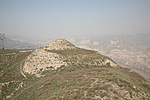
Details:长城类别:墙体
起点经纬高度:东经:104° 01′ 北纬:36° 03′ 海拔:1506
终点经纬高度:东经:103° 57′ 北纬:36° 03′ 海拔:1522
墙体走向:
墙体类别:山险
结构特点及构筑方式:山体陡峭崎岖,沟壑纵横,又有黄河自然天险,山体坡度一般在300-500,海拔在1500米--1700米之间,山体相互连接。
起自第0110点,止于兰州市城关区桑园子至拱星墩长城第0124点,全长5200米。山险从罗泉湾长城止点第0110点起,沿黄河南岸山脊逐渐向西经过木瓜台、东坪,再穿过陇海铁路和县乡公路,经李家窑、虎屲山、营盘山至桑园子铁路大桥与兰州市城关区东岗镇桑园子至拱星墩长城相接。
现状:
Type:山险 Precipitous mountain areas
Protection Level:
Content:
Memo:
Other Records:
Distribution:
visit location in Tianditu Map[recommend] Distribution:
visit location in Tencent QQ Map Distribution:
visit location in Google MapDistribution:
visit location in Baidu MapNational ID:620123382106170006
Action:[
 Save in Data Basket
 ]
Picture:
Click the thumbnail to view the Big Pic. Click the Big Pic to Hide the Big Pic![Caption:桑园子山险
loading images --Please wait...]()
![Caption:桑园子山险
loading images --Please wait...]() Photo Links
Photo Links:
 Search ::
  Favorite/My Favorite :: Recent Changes :: :: Login