Welcome you Visit www.thegreatwall.com.cn!!     Location:EN Version->The Great Wall Architecture and Geographical Information Database[ Login ]/[ Register ]  
 Home :: Regional Index :: List :: Search :: My Data Basket :: Favorite/My Favorite :: Recent Changes :: :: Login
Official Name:羊圈墩(敌台)
YangQuanDunDiTai
Our Name:无  / Wu
Other Name: /
Period:明 / Ming Dynasty 1368~1644
Location: 甘肃省,武威市,民勤县,重兴乡下案村麻家湖西3.7千米 / GanSuSheng,WuWeiShi,MinQinXian,ZhongXingXiangXiaAnCunMaJiaHuXi37QianMi
         [Looking Local List]
Details:长城类别:单体建筑 经纬高度:东经:102° 47′ 北纬:38° 21′ 海拔:1419 建筑形式:不明。 起自0028点,止于0029点,全长5900米。整段处于红水河东岸,腾格里沙漠西部边缘,因洪水冲刷、流沙埋压,或因早期开发而消失殆荆 材料: 附近遗存:东南与四方墩至十二墩河险相接,起点为十二墩(烽火台),止点0029点,西北与五墩汉长城1段相接。五墩2号烽火台位于消失段西侧约500米,西距明代岸门至五墩长城、五墩长城1段、2段、3段约1千米。
Type:敌台 Defence Tower
Protection Level: 
Content:
Memo:
Other Records:
Distribution:visit location in Tianditu Map[recommend]
Distribution:visit location in Tencent QQ Map
Distribution:visit location in Google Map
Distribution:visit location in Baidu Map
National ID:620621352101170044
Action:[ Save in Data Basket ]
Picture: Click the thumbnail to view the Big Pic. Click the Big Pic to Hide the Big Pic
羊圈墩(敌台)     
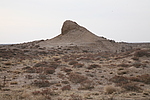
Caption:羊圈墩(敌台)
Photo Time:2007-12-15 16:38:36
Photo Contributor:甘肃省文物局
[Open in New Window]  
Caption:羊圈墩(敌台)
loading images --Please wait...
羊圈墩(敌台)     
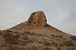
Caption:羊圈墩(敌台)
Photo Time:2007-12-15 16:41:05
Photo Contributor:甘肃省文物局
[Open in New Window]  
Caption:羊圈墩(敌台)
loading images --Please wait...
羊圈墩(敌台)     
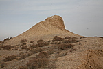
Caption:羊圈墩(敌台)
Photo Time:2007-12-15 16:42:08
Photo Contributor:甘肃省文物局
[Open in New Window]  
Caption:羊圈墩(敌台)
loading images --Please wait...
羊圈墩(敌台)     
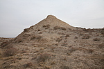
Caption:羊圈墩(敌台)
Photo Time:2007-12-15 16:43:24
Photo Contributor:甘肃省文物局
[Open in New Window]  
Caption:羊圈墩(敌台)
loading images --Please wait...
Photo Links:

 the Page History :: Edit Photo :: Manager Area: Confirm :: Restore :: Delete
 评论/讨论/留言区 :: 发表新帖 :: 刷新 :: 回到顶部
 留言总数0帖 页次:1/0 每页:20条 
v0.1 2003; v1.3 2022.05 ; © 2003~2022,www.thegreatwall.com.cn