Official Name:
上牛还村西长城ShangNiuHuanCunXiChangChengOur Name:
/
Other Name:
/
Period:明 / Ming Dynasty 1368~1644
Location: 山西省,大同市,浑源县,起于王庄堡镇上牛还村西南2.5千米,止于王庄堡镇西河口村东南1.5千米。 / ShanXiSheng,DaTongShi,HunYuanXian,QiYuWangZhuangBaoZhenShangNiuHuanCunXiNan25QianMiZhiYuWangZhuangBaoZhenXiHeKouCunDongNan15QianMi
[
Looking Local List]
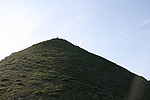
Details:长城类别:墙体
起点经纬高度:东经:113° 52′ 北纬:39° 22′ 海拔:1656
终点经纬高度:东经:113° 50′ 北纬:39° 23′ 海拔:1685
墙体走向:东南-西北。
墙体类别:山险
结构特点及构筑方式:无。无。
现状:山险。
Type:山险 Precipitous mountain areas
Protection Level:省保
Content:
Memo:
Other Records:
Distribution:
visit location in Tianditu Map[recommend] Distribution:
visit location in Tencent QQ Map Distribution:
visit location in Google MapDistribution:
visit location in Baidu MapNational ID:140225382106170001
Action:[
 Save in Data Basket
 ]
Picture:
Click the thumbnail to view the Big Pic. Click the Big Pic to Hide the Big Pic![Caption:上牛还村西长城
loading images --Please wait...]() Photo Links
Photo Links:
 Search ::
  Favorite/My Favorite :: Recent Changes :: :: Login