Official Name:
乌兰哈达界壕9段WuLanHaDaJieHao9DuanOur Name:
/
Other Name:
/
Period:金 / Jin Dynasty 1115~1234
Location: 内蒙古自治区,通辽市,扎鲁特旗,起点:巴雅尔胡硕镇乌兰哈达嘎查西南5.2千米止点:巴雅尔胡硕镇乌兰哈达嘎查西南5.5千米 / NeiMengGuZiZhiQu,TongLiaoShi,ZhaLuTeQi,QiDianBaYaErHuShuoZhenWuLanHaDaGaChaXiNan52QianMiZhiDianBaYaErHuShuoZhenWuLanHaDaGaChaXiNan55QianMi
[
Looking Local List]
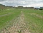
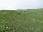
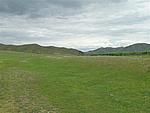
Details:长城类别:界壕壕堑
起点经纬高度:东经:° ′ 北纬:° ′ 海拔:
终点经纬高度:东经:° ′ 北纬:° ′ 海拔:
墙体走向:东北-西南走向。
墙体类别:界壕
结构特点及构筑方式:墙体基础为自然基础,黑沙土、碎石混合堆筑。
现状:土墙。该段长城墙体总长342米,底宽8.2-12.2米、顶宽2-5米、高1-5米。墙体总体保存较好。保存较好段落全长294米,保存一般段落全长48米,分别占全长86%、14%,该段墙体的GPS0018点为马面。基本呈东北-西南走向,底宽顶窄,低矮扁平,起伏不一,已不见附属设施。大多数墙体在草地中,有的墙体处于耕地中,土墙呈高低不平的土垄状,墙体上长满长草、杂草。
Type:界壕、壕堑 Boundary trench, fosse
Protection Level:国保
Content:
Memo:
Other Records:
Distribution:
visit location in Tianditu Map[recommend] Distribution:
visit location in Tencent QQ Map Distribution:
visit location in Google MapDistribution:
visit location in Baidu MapNational ID:150526382201150012
Action:[
 Save in Data Basket
 ]
Picture:
Click the thumbnail to view the Big Pic. Click the Big Pic to Hide the Big Pic![Caption:乌兰哈达界壕9段
loading images --Please wait...]()
![Caption:乌兰哈达界壕9段
loading images --Please wait...]()
![Caption:乌兰哈达界壕9段
loading images --Please wait...]() Photo Links
Photo Links:
 Search ::
  Favorite/My Favorite :: Recent Changes :: :: Login