Official Name:
后坝口长城第1段HouBaKouChangChengDi1DuanOur Name:
宣化县长城第39段(娘娘山长城墙体) / XuanHuaXianChangChengDi39DuanNiangNiangShanChangChengQiangTi
Other Name:
/
Period:明 / Ming Dynasty 1368~1644
Location: 河北省,张家口市,宣化县,宣化县李家堡乡后坝口村东约3.0千米 / HeBeiSheng,ZhangJiaKouShi,XuanHuaXian,XuanHuaXianLiJiaBaoXiangHouBaKouCunDongYue30QianMi
[
Looking Local List]
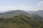
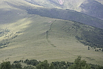
Details:长城类别:墙体
起点经纬高度:东经:115° 26′ 北纬:40° 45′ 海拔:1903
终点经纬高度:东经:115° 28′ 北纬:40° 44′ 海拔:1519
墙体走向:西北--东南。
墙体类别:石墙
结构特点及构筑方式:毛石垒砌。
不同时代叠压关系:无。
现状:位于宣化与赤城两县交界山脊上,毛石墙体,破坏严重,大部分为土石垄,全长约3465米。两侧草甸。
按保存程度,分为2段
第一段(宣附拐10-宣附山险段)保存差,长2290米。
起点坐标:东经:115°26′25.10″北纬:40°45′19.20″高程:1903米
止点坐标:东经:115°27′50.60″北纬:40°44′27.40″高程:1655米
第2段(宣附山险段-宣附断点001)以消失,长1175米
起点坐标:东经:115°27′50.60″北纬:40°44′27.40″高程:1655米
止点坐标:东经:115°28′35.40″北纬:40°44′10.10″高程:1519米
Type:石墙 Stone wall
Protection Level:省保
Content:
Memo:
Other Records:
Distribution:
visit location in Tianditu Map[recommend] Distribution:
visit location in Tencent QQ Map Distribution:
visit location in Google MapDistribution:
visit location in Baidu MapNational ID:130721382102170039
Action:[
 Save in Data Basket
 ]
Picture:
Click the thumbnail to view the Big Pic. Click the Big Pic to Hide the Big Pic![Caption:后坝口长城第1段
loading images --Please wait...]()
![Caption:后坝口长城第1段
loading images --Please wait...]() Photo Links
Photo Links:
 Search ::
  Favorite/My Favorite :: Recent Changes :: :: Login