Official Name:
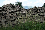
白塔沟长城BaiTaGouChangChengOur Name:
/
Other Name:
/
Period:明 / Ming Dynasty 1368~1644
Location: 河北省,张家口市,赤城县,赤城县龙关镇方家沟村北约0.8千米 / HeBeiSheng,ZhangJiaKouShi,ChiChengXian,ChiChengXianLongGuanZhenFangJiaGouCunBeiYue08QianMi
[
Looking Local List]
Details:长城类别:墙体
起点经纬高度:东经:115° 30′ 北纬:40° 47′ 海拔:1351
终点经纬高度:东经:115° 27′ 北纬:40° 47′ 海拔:1715
墙体走向:东--西。
墙体类别:石墙
结构特点及构筑方式:干叉片石墙体,设登城步道1处,马面2座。
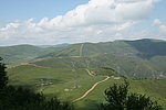
现状:位于白塔沟北侧山脊上,北侧约2.5千米为通往夭湾的乡村公路,墙体两侧为宜林山地,墙体为干叉毛石,破坏严重,全长约6300米,分11段。
第一段:“二架山长城断点002”【地理坐标:东经:115°30′51.10″;北纬:40°47′39.80″;高程:1351米】向西至“白塔沟长城拐点014”【地理坐标:东经:115°29′18.20″;北纬:40°48′01.90″;高程:1748米】,长约2745米,保存较差。墙体残存较矮,多为碎石及砂土,墙体高1.2米~1.7米,宽1.5米~3.5米。
Type:石墙 Stone wall
Protection Level:省保
Content:
Memo:
Other Records:
Distribution:
visit location in Tianditu Map[recommend] Distribution:
visit location in Tencent QQ Map Distribution:
visit location in Google MapDistribution:
visit location in Baidu MapNational ID:130732382102170159
Action:[
 Save in Data Basket
 ]
Picture:
Click the thumbnail to view the Big Pic. Click the Big Pic to Hide the Big Pic![Caption:白塔沟长城
loading images --Please wait...]()
![Caption:白塔沟长城
loading images --Please wait...]() Photo Links
Photo Links:
 Search ::
  Favorite/My Favorite :: Recent Changes :: :: Login