Official Name:
花场峪北沟石城HuaChangYuBeiGouShiChengOur Name:
空营 / KongYing
Other Name:
/
Period:明 / Ming Dynasty 1368~1644
Location: 河北省,秦皇岛市,抚宁县,花场峪北沟村西北0.3千米 / HeBeiSheng,QinHuangDaoShi,FuNingXian,HuaChangYuBeiGouCunXiBei03QianMi
[
Looking Local List]
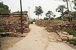
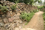
Details:长城类别:关堡
经纬高度:东经:119° 31′ 北纬:40° 9′ 海拔:295
总体情况:仅存部分石墙,保存较好。四面边墙,残宽3.2米~3.8米,残高1米~3米,均保存当初的建筑形制,坍塌严重,于西面墙体上残存垛口墙痕迹,宽0.9米。
附近遗存:
Type:堡 Fort
Protection Level:省保
Content:
Memo:
Other Records:
Distribution:
visit location in Tianditu Map[recommend] Distribution:
visit location in Tencent QQ Map Distribution:
visit location in Google MapDistribution:
visit location in Baidu MapNational ID:130323353102170033
The original number submitted by the local government :130323353102170020
(when the Great Wall is identified, the data whose code has been adjusted will display the original number submitted by the local government before revision, which can be used by the local cultural relics department when checking the local data.)
Action:[
 Save in Data Basket
 ]
Picture:
Click the thumbnail to view the Big Pic. Click the Big Pic to Hide the Big Pic![Caption:花场峪北沟石城
loading images --Please wait...]()
![Caption:花场峪北沟石城
loading images --Please wait...]() Photo Links
Photo Links:
 Search ::
  Favorite/My Favorite :: Recent Changes :: :: Login