| [ Login ]/[ Register ] |
 Search ::
  My Data Basket ::
  Favorite/My Favorite :: Recent Changes :: :: Login Save in Data Basket ]
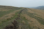
| Caption:后窑长城3段 Photo Time:2008-06-05 12:19:46 Photo Contributor:内蒙古自治区文物局 [Open in New Window] |
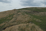
| Caption:后窑长城3段 Photo Time:2008-06-05 12:24:01 Photo Contributor:内蒙古自治区文物局 [Open in New Window] |
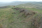
| Caption:后窑长城3段 Photo Time:2008-06-05 12:28:27 Photo Contributor:内蒙古自治区文物局 [Open in New Window] |
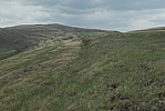
| Caption:后窑长城3段 Photo Time:2008-06-05 12:48:04 Photo Contributor:内蒙古自治区文物局 [Open in New Window] |